Scale and Resolution

SCALE

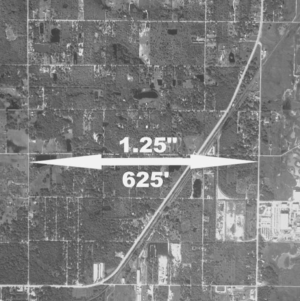
In the picture to the left, the actual measurement of the area between the two roads on the image is 1.25 ". The actual measurement of the same area as measured on the ground is 625 feet.

To calculate the scale of this image: divide 625 (actual real life measurement) by the 1.25 (distance as measured on the image ). The resulting numerical value is the scale of the image.

Scale is written this way: 1"=500' +/-


(note: adding +/- to the end of the scale acknowledges that this is only a close calculation.)

We use 7.5 minute series USGS topographical quadrangle maps to calculate the actual ground measurement.


Resolution

Resolution pertains to the density of the pixels in a scanned image. Resolution is referrenced as pixels per inch (ppi). This is the number of pixels in a linear inch in the image. So, if the ppi is fixed on an image, then increasing the size of the image (and scale) would decrease the ppi of that image.


Resolution / Scale

Some industries refer to the resolution of a scanned image in terms of the one pixel to a measurement of an actual object in the image. For example, 1 pixel = 6" of ground measurement. This terminology mixes resolution with scale. In order to get this type of resolution, scale or ppi should be given. In the following table the combinations of scale and ppi will result in 1 pixel = 6":


Image to Ground Scale Pixels Per Inch
1"=2000' 4000 ppi
1"=1000' 2000 ppi
1"=500' 1000 ppi
1"=300' 600 ppi
1"=200' 400 ppi

Note: as the ppi of an image increase so does the file size.