Vertical Examples
Click on image to enlarge
Images are scaled using USGS topographical maps or images are geo-coded and
rectified using DOQQS. DOQQs are produced by the Texas Orthoimagery Program
and are acturate to 1 meter. Images can be printed
on photographic paper and or copied to CD, DVD or an FTP site for delivery
to the customer.
The size of each image is 9" X 9" if from film. The footprint of each
digital image is 4.5" x 6" at 1200 dpi. The negative scale of each image is
determined by the altitude flown. The negative scale can then be enlarged to
5 times from film and 8 times if digital to reach the desired print scale.
All new imagery is shot in digital format only.
Chemical Turning
and Avery Turning Basins
This photo was taken at a negative scale of 1"=1600'.
The area covered as shown is approximately 2.1 miles X 1.7 miles.
This photo was cropped from the original negative. |
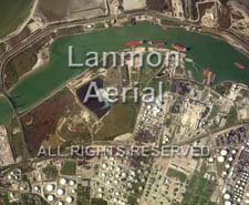
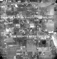
Padre Complex
This photo was taken at a negative scale of 1"=2500'. The
area covered as shown is approimately 3.3 miles X 3.25 miles. |
|
| |
|
|
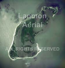
Shamrock Island
Because island shorelines are
changing, scaling this image is more of a challenge. Using
previously taken photos and topographical maps scale was set at
approximatley 1"=750'.
|
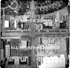
Accident Site Hwy 244 & Loop 12,
Garland, TX
Accident sites are normally shot at a low altitude,
marks are painted on the road at 100' intervals. This allows a more
acurate scale to be set in the darkroom The negative scale of this
image was shot at 1"=150'. The printed scale was 1"=30'. |
|
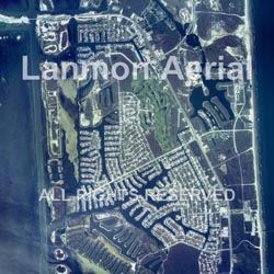
Clarkwood, TX
The scale of this image is 1"=500'. The area as shown covers
approximately 3909' X 3700' on the ground. This image was cropped
from the original negative and scaled up (enlarged). The orginal
negative scale of this image was 1"=1000'.
|
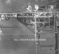
Airline @ Cimarron Blvd
The negative scale of this image is 1"=2000'. The
scale was set by measuring the actual distance on the image between
Cimarron and Rodd Field Road then dividing 5280' (1 mile) by that
measurement. The ground distance between the two roads is 1 mile as
measured on the USGS topographical map.
Rio
Grande Valley TX Aerial Imagery |
Aerial Photography Rio
Grande Valley |
Corpus Christi Aerial Imagery |
Historical Aerial
Photography Corpus Christi TX |
Historical Aerial
Photography Rio Grande Valley TX |
|
|
| |
|
|